 |
North-west view of the castleThe castle of the Velasco, also called the Palace of the Constables of Castile, was probably built in the 12th century, during the repopulation of King Ferdinand II of Leon, who granted the town a charter in 1179. It was a lordship of the Order of the Temple until its dissolution in 1312. During the War of the Communities, the castle was burned down, and Constable Don Iñigo built a palace on its ruins. Two canvas of the castle wall remain, and in the north corner, a circular tower, which may have served as a homage tower, is located. In the basement is the dungeon where the Dauphin of France and the Duke of Orleans, sons of Francis I, King of France, were held prisoner for more than two years, hostages of Spain due to the French defeat at Pavia. |
Mostrando entradas con la etiqueta Autonomous Community of Castilla y León. Mostrar todas las entradas
Mostrando entradas con la etiqueta Autonomous Community of Castilla y León. Mostrar todas las entradas
30/4/25
Castle of Villalpando (Zamora)
5/2/25
Castle of Villagarcía de Campos (Valladolid)

|
Eastern view of the castleThe castle-palace of Doña Magdalena de Ulloa was built around 1336, during the border struggles between the kingdoms of León and Castile. In its time it was a major work, currently consisting of a stone-cut homage tower, an old breadbasket rebuilt and two access gates, one of which is entered by a drawbridge. During the 15th century, palatial rooms were built by order of the Quijada family. Jeromín, the natural son of Emperor Charles I of Spain, who later became known as Don Juan of Austria, was educated there anonymously. |
3/11/24
Castle of Olmillos de Sasamón (Burgos)
 |
South-west view of the castleThe Cartagena castle is a fortress built in 1446 by Pedro de Cartagena, alderman of Burgos in the town of Olmillos de Sasamón. It was built as a stately palace, consisting of a rectangular floor plan with circular towers at the corners, perfectly maintaining circular machicolations crowning the cubes and gyratories. On its walls you can distinguish blazons with the fleur-de-lis of the coat of arms of the Cartagena family, the most powerful Jewish-convert family in late medieval Spain. Ownership of the castle has passed through the hands of various families and owners (the Valoria lineage, the ducal house of the Gor, the Arteche family). Around 1989 the San José family bought the castle and after restoring it they used it as a hotel. |
Olmillos de Sasamón
 |
View of the town from the terrace of one of the castle towersOlmillos de Sasamón is a town belonging to the municipality of Sasamón, in the province of Burgos in the Autonomous Community of Castilla y León, located in the region of Odra-Pisguerga. In Olmillos there are Celtiberian archaeological sites on the nearby hill of Castarreño, with vestiges of the ancient Segisama turmoga. Around the year 880 a repopulation took place after the Reconquista, almost at the same time as in nearby Castrojeriz and already during the Middle Ages it was one of the fundamental points on the Camino de Santiago, with two pilgrim hospitals. |
7/8/24
Villapadierna
 |
Cubillas de Rueda Town HallVillapadierna is a town belonging to the municipality of Cubillas de Rueda, in the province of León in the Autonomous Community of Castilla y León. It is located in the north of the province and is 51 km from the capital of León and 5 km from its town hall. This region south of the Cantabrian mountain range is believed to have belonged to the Vadinienses tribe, who fought against Roman troops in the Cantabrian Wars, until they eventually accepted their rule and culture. The terms paternus and maternus were used in the Middle Ages as personal names, "Padierna" derived from paterna, so Villapadierna means paternal town or town of Paterno. |
11/7/24
Castle of San Pedro de Latarce (Valladolid)
 |
North view of the castle from the bridge that crosses the Sequillo riverThe castle of San Pedro de Latarce is one of the defensive buildings ordered to be built by King Alfonso IX of León, to reinforce the border against the kingdom of Castile at the end of the 12th century. Later in the Middle Ages, a castle of formwork masonry would be built on it, which included a large gate tower (during the time of María de Molina), becoming the property of the Knights Templar. It has an oval floor plan and was renovated by the Bazán family throughout the 15th century. Currently its general condition is one of progressive ruin, with only a closed wall of approximately 350 meters standing, being municipal property since 2013. |
15/5/24
Castle of Granucillo (Zamora)

|
North view of the castle from the path of the hermitage ofSanto Cristo de San AdriánThe castle-palace of the Counts of Benavente was built before the year 1446 by members of the Escobar family, who were lords of the town, who obtained this territory through a donation from King Henry III of Castile, being transferred at the end of the 15th century. to the Pimentel family, Counts of Benavente. Only the walled perimeter located on a small hill next to the Almucera stream is preserved, and inside the foundations and the lower part of the homage tower. |
Granucillo
 |
Town HallGranucillo is a municipality of the province of Zamora in the Autonomous Community of Castilla y León, located in the region of Benavente and Los Valles, sub-region of Vidriales. It is characterized by its rich landscape and the numerous vestiges of the past, with the dolmens of Las Peñezuelas and San Adrián, which show the existence of settlement human since the Bronze Age. In the Middle Ages it was integrated into the Kingdom de León, whose monarchs undertook the repopulation of the town, to later integrated into the Lands of the Count of Benavente. |
19/3/24
Castle of Zumel (Burgos)
 |
South-west view of the castleThe castle of Zumel was built in the mid-15th century, although its origin may have been earlier, by Pedro Yáñez de Ulloa, chief chancellor of King Juan II. Inside the castle, the homage tower stands out, which stands in the northwest corner of the parade ground. More than a defensive fortress, it served as a tower-palace, demonstrating the high economic position of its owners. In 1516 it passed into the hands of the Bernuy family of converted Jewish origin from Burgos, important and influential in European trade in the 16th century, which extended commercially to North Africa, America and the Azores Islands. |
Zumel
 |
Zumel administrative boardZumel is a town belonging to the municipality of Valle de Santibáñez, in the province of Burgos in the Autonomous Community of Castilla y León, it belongs to the region of Alfoz de Burgos. It is located on the banks of the Urbel River, and is documented in a manuscript from the Oña monastery, from the first years of the 11th century, when the place appeared repopulated by Basque immigrants, who gave it the name Zumel (wicker tree), although its origin may be be previous. |
30/12/23
Castle of Villanueva de Jamuz (León)
 |
North view of the castleThe castle of the Quiñones was built throughout the first half of the 15th century at the initiative of Don Diego Fernández de Quiñones, the future Count of Luna from the year 1462. It has a quadrilateral plan, with towers in three of its corners. In its north-east wall there is a central cube where the entrance to the castle is located and an ashlar on which the weapons of D. Suero de Quiñones, the protagonist of “El Paso Honroso” in Hospital de Órbigo, are sculpted, which reads the phrase “Honor or end.” Inside is the parade ground and the homage tower, with the heraldic shields of Don Diego and his wife María de Toledo. It had four floors and was crowned with a projecting cornice supported by modillions. The first floors served as the lords rooms and rest chambers. |
Villanueva de Jamuz
 |
Town Hall of the Santa Elena de JamuzVillanueva de Jamuz is a town belonging to the municipality of Santa Elena de Jamuz, in the province of León in the Autonomous Community of Castilla y León, it belongs to the Tierra de La Bañeza region. The town would have been founded around the 11th century, where it is already documented. At first it was known as Villanueva de Don Vermúdez, a figure of the Leonese nobility, and during the 13th and 14th centuries it was renamed Villanueva de Simón Sánchez, a relative of the previous Vermúdez. From this century onwards, Villanueva, together with nearby towns, became the Council or Jurisdiction of Valdejamuz in the hands of the powerful family of the Quiñones-Counts of Luna, in turn relatives of the previous ones. |
1/9/23
Castle of Las Navas del Marqués (Ávila)
 |
South-east view of the castle from outside the townThe castle-palace of Magalia was built in 1540 by the first Marquises of Las Navas, Don Pedro Dávila y Zúñiga and his wife, Doña María de Córdoba, who used it as the residence and administrative center of their marquisate. It is located in the Sierra de Guadarrama, where the southern slope of the Central Mountain Range takes the name of Sierra de Malagón. The complex highlights the main façade with projecting balconies, Renaissance windows and an entrance door with a semicircular arch, the stone hallway and the patio with two galleries, as well as two flat stone vaults located in one of the towers. These vaults are unique in the world, since there is only one other in the Royal Monastery of El Escorial. In the 18th century the building was abandoned and finally sold in 1906, along with the Las Navas lands, to the Resinera Española company, which later gave it to the State to use it for cultural purposes. It is currently managed by the Ministry of Culture and Sports. |
Las Navas del Marqués
 |
South-west view of the townLas Navas del Marqués is a municipality in the province of Ávila, in the Autonomous Community of Castilla y León, it belongs to the Valle del Alberche and Tierra de Pinares region, being the most populated municipality. It is located on the southern slope of the Sierra de Malagón and borders the Autonomous Community of Madrid, characterized by its extensive natural environment. The existence of anthropomorphic rock tombs prove human settlements during the Early Middle Ages, probably shepherds who used these lands as they were “no man's land”, nestled between the Christian south and the Muslim north, but the town as such is not documented until late. from the 13th century. |
29/6/23
Castle of Grajal de Campos (León)
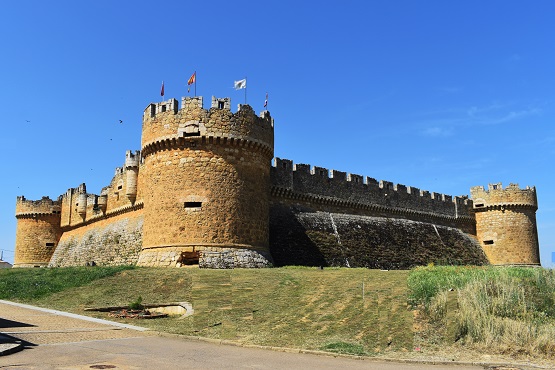 |
Eastern view of the castleThe castle of Grajal de Campos is a military construction from the 16th century, designed by the architect Lorenzo de Aldonza on the remains of another previous castle from the 10th century. It is considered the first artillery castle in Spain. It was built between 1517 and 1521 by order of Hernando de Vega, and finished by his son Juan de Vega, first count of Grajal de Campos. It has a quadrangular plan with four towers where the largest caliber cannons were located. In the past, it was isolated by a moat with a drawbridge and an entrance door, all of which is currently buried, and its exact location has not been found. According to an 18th century manuscript, it was located on the southern side of the complex. It is built on a pronounced slope and the mote itself and the rubble were used to embank the indoor of the fortress and achieve the current platform that surrounds its walls. |
12/12/22
Castle of Laguna de Negrillos (León)
 |
Western view of the castleThe castle of Laguna de Negrillos already existed around the year 1205, the date on which King Alfonso IX of Leon granted a charter to the population. The reconstruction of the castle as we see it today was carried out by Don Diego Fernández de Quiñones and Doña María de Toledo, in the 15th century. It is located in the Páramo leonese region and is 42 km away. of Leon capital. It has a square plan and has a homage tower with five floors and all battlements at the top, in the north-west outer corner and a rectangular tower called the Queen's tower in the north-east interior of the parade ground. |
Laguna de Negrillos
 |
Town HallLaguna de Negrillos is a municipality in the province of León in the Autonomous Community of Castilla y León, located to the south of the Páramo Leonés region and very close to the Órbigo and Esla rivers, passing through it a small stream, called Regueral. During the twelfth century under the reigns of Fernando II and his son Alfonso IX, the name as such of "Lacuna de Negrillis" was mentioned repeatedly, the town being handed over to Suero Rodríguez. In 1205 Alfonso IX grants it a charter to the town, in which most of the precepts contained in it present a notable similarity with those of the charter of León capital. |
8/2/21
Castle of Auqueospese (Ávila)
 |
East view of the castleThe castle is located on the crags of the foothills of the Sierra de la Paramera, overlooking the Amblés valley. It has an fitful shape and blends in with the rocks where it sits. It is mentioned in documents from the 11th and 12th centuries making reference to war and reconquest expeditions against the Arabs, being the Dávila lineage who rebuilt the current castle during the 13th century as a result of the battle of Las Navas de Tolosa. It is also known as the castle of the Risco or castle of Manqueospese. |
Mironcillo
 |
View of the town and the castle from the banks of the Fortes riverMironcillo is a municipality in the province of Ávila in the Autonomous Community of Castilla y León. It belongs to the Valle del Amblés region and part of its territory is included in the natural area of the Sierras de la Paramera and la Serrota. The municipality is bathed by the Garganta river, which rises near Zapatero peak (2,146 meters) and runs from south to north. |
8/1/21
Castle of Urueña (Valladolid)
 |
East view of the castleThe castle was ordered to be built during the 11th century by the castilian king Fernando I the Great, on the remains of an old roman fortification. Influential characters in castilian history resided in it, such as queen Doña Urraca (12th century) or María de Padilla, lover of the monarch Pedro I el Cruel (14th century). Located in the extreme southeast of the town, it has a rectangle shape with semicircle towers along its entire perimeter, except for the one to the south, where the homage tower is located, which is square in shape. Nowadays, it only conserves the outer walls and inside, since 1832, the municipal cemetery. Urueña preserves 80% of the walled enclosure that originally surrounded the entire population. |
Suscribirse a:
Entradas (Atom)